Thursday, August 30, 2007

Returning...

Well, holidays are finished and we come back to the work. I didn't spend much time on the project but in my free time I did:
  • improved the WMS wizard,
  • added tilt rotation to the camera (similar to the WWJ), and also
  • I have started to play the WWJ source code.

As a result of this third point I show you a screenshot:


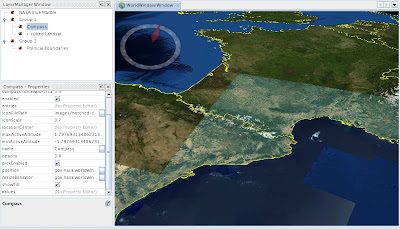
In there is no direct way to group layers, because this I have create a LayerSet class that can group layers.

The image shows the layers: BMNG, compass, landsat and finally country boundaries.

Thursday, August 02, 2007

More improvements

Finally I'm on holidays. Also I have finished refactoring the core API to work with listeners (take a look at previous post).

Today I want to post about a couple of new user interface improvements I have made thanks to the previous work.
Now, when the user loads some data (image, shapefile or WMS layer) a progress bar is shown:


And once the data is loaded, depending if the data can or can't be loaded, the label in the layer explorer change its color to show the final state: